



IMMISbuildoffers a semi-automatic procedure to derive IMMISluft compliant road sections from generally available data and provides a powerful editor for IMMISluft section attributes. IMMISbuild is available as Extension for ArcGIS®. The semi-automatic procedure of section generation uses data on
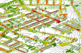
IMMISbuild internally combines the data into a comprehensive model, detects homogenous street sections (e. g. street canyons) and computes all necessary parameters to describe the geometry of for the screening model IMMISluft. The procedure generates an IMMISluft database in an objective and effective way. The database can be refined with the help of the IMMISbuild-editor. The editor provides interactive access to all relevant geometric parameters of a selected IMMISluft section like length, porosity, width and height of canyon, or road gradients. Furthermore it can simultaneously visualise canyon extends and section porosity and supports the automatic recalculation for canyon related parameters while merging one ore more sections together. | |
 | Features
|